Why driving in Georgia can get confusing
Here is a prime example. This is a road we take to get to my doctor’s office.
We start on this road near its beginning as Shiloh Rd NW (lower left yellow road). Not too long after that it changes to Shallowford Rd NW. Then Shallowford Rd NE.
Then the same road turns into Jamerson Rd NE. Or does it? The physical road “continues” quite seamlessly as Jamerson, but “Shallowford Rd NE” actually doesn’t disappear. Look just before the words “Jamerson” and you’ll see the Shallowford actually veers off to the right, then hits Canton Hwy. As if this is not enough, notice the bottom right yellow road–it’s Shallowford again!
I realized this “road” was basically cut in half when I was driving up another road (to the right of this map) and became confused by seeing that I was passing Shallowford. I suddenly wasn’t completely sure where I was. :) Our inch-thick street map of the area is definitely a necessity!
And lest you think this is a one-of-a-kind case, here’s another one:
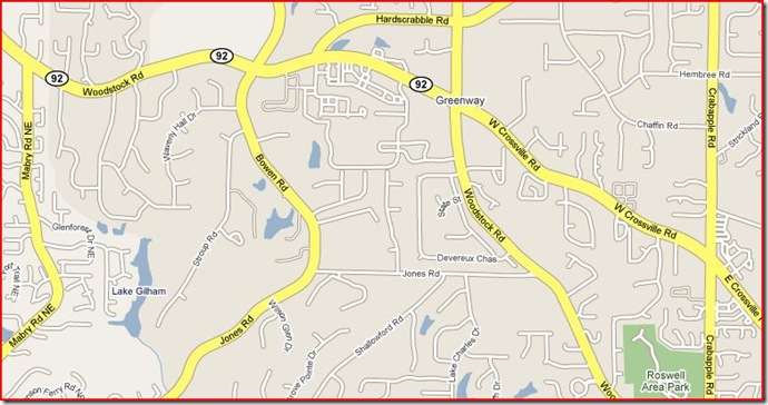
Take a look at Woodstock Rd (top left corner). It also does a sharp veer to the right, with the physical road becoming W Crossville Rd. That intersection is actually a pretty big one, complete with stoplight and signs. From experience, it is really confusing to be heading west on Crossville (for the first time), knowing from Google that you will “continue” onto Woodstock only to come to an intersection which clearly tells you that Woodstock is on your left.
(And if you’re really astute you will also see a small Shallowford Rd on the bottom middle of the above map. The “cut in half” Shallowford Rd NE again changes names near its end, but this time the street name veers off to the left, becomes a smaller road, and loses the NE, at least according to Google. I just recently noticed that.)
On the plus side, the scenery is absolutely beautiful along many of these roads. But sometimes I sure do miss Utah, where I was used to being able to find any address based solely on the N/S and E/W coordinates! :) Though I guess you could argue that even those roads sometimes disappear and reappear (like when a park or large University get in the way). Maybe it all just comes down to what you’re used to. :)


wow!!! i would surly not make it there. I depend on my knowlege of the grid system. no matter what you can generally find your way around. :)
Yeah, most people we’ve met who aren’t native to the area just throw up their hands in defeat and buy a GPS. So far we’ve resisted it (mostly because the model I want is $350), but have consequently come to rely on printing directions from Google Maps and referring to our big book of city maps we keep in the van whenever we get lost.
Interestingly enough, just the other day I remarked to Cassia that I was becoming quite familiar with these labyrinthine Georgia roads – so much so that going back to a street plan based on the coordinate grid would throw me for a loop! Wait a second . . . this road doesn’t curve incessantly! Or change its name at least three times over the course of two miles! What kind of backwards place is this?!